University of Minnesota
http://www.umn.edu/
612-625-5000
http://www.umn.edu/
612-625-5000
Minnesota Biodiversity Atlas
Bell Museum
Dataset: MIN-Bryophytes
Search Criteria: United States OR USA OR U.S.A. OR United States of America; Arkansas; excluding cultivated/captive occurrences
1
Page 1, records 1-16 of 16
Bell Museum bryophytes | |
 MIN:Bryophytes |  Aulacomnium palustre (Hedw.) Schwägr. 501000[1100280] 69511954-06-18 United States, Arkansas, Logan, West end Magazine Mountain |
MIN:Bryophytes |  Bryoandersonia illecebra (Hedw.) H. Rob. 731133[1107732]P.L. Redfearn, Jr. 164151965-02-06 United States, Arkansas, Franklin, Ca. 5 miles north of Cass, vicinity of Cherry Bend Recreation Area, Ozark National Forest, 35.743277 -93.814891, 701m |
MIN:Bryophytes | 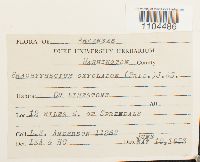 Brachythecium oxycladon (Hedw.) Austin 621730[1104486]L.E. Anderson 112821953-06-10 United States, Arkansas, Washington, 12 miles E. of Sprindale |
MIN:Bryophytes | 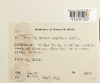 Fontinalis novae-angliae Sull. 500527[1129759]Welch 21521934-07-05 United States, Arkansas, Faulkner, Cedar Park, 6 mi. NW of Conway, 35.175732 -92.442101 |
MIN:Bryophytes | 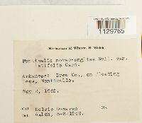 Fontinalis novae-angliae var. latifolia Card. in Nichols 500536[1129765]Delzie Demaree s.n.1942-05-02 United States, Arkansas, Drew |
MIN:Bryophytes | 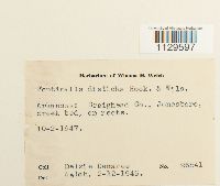 Fontinalis disticha Hook. & Wils. in Drumm. 500515[1129597]Delzie Demaree 265411949-02-12 United States, Arkansas, Craighead, Jonesboro |
MIN:Bryophytes | 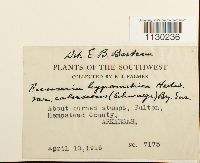 Funaria hygrometrica var. calvescens (Schwägr.) Mont. 379640[1130236]Palmer, J. 71751915-04-10 United States, Arkansas, Hempstead, Fulton |
MIN:Bryophytes |  Fissidens subbasilaris Hedw. 731132[1130095]Jr., Paul L. Redfearn 175241965-07-06 United States, Arkansas, Franklin, 2 miles south of Cass. Sec. 19-20, R. 26 W, T. 12 N., 305m |
MIN:Bryophytes |  Hygroamblystegium fluviatile (Hedw.) Loeske 17567[1133013]Jerry A. Snider 13001970-03-25 United States, Arkansas, Stone, Along forest road, above Gunner Pool near town of Fifty-six |
MIN:Bryophytes |  Leucobryum albidum (Brid. ex P. Beauv.) Lindb. 733839[1139902]Quinn, Robert 4981979-10-05 United States, Arkansas |
MIN:Bryophytes |  Leptodictyum riparium (Hedw.) Warnst. 501035[1140186] 69331954-06-15 United States, Arkansas, Washington, Ozark Trout Farm Johnson |
MIN:Bryophytes | 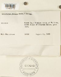 Leucobryum glaucum (Hedw.) Ångström 437602[1140272]Whitehouse, Eula 238281950-08-23 United States, Arkansas, Scott, 8 miles south of Waldren, north slope of Fourche River; pine belt |
MIN:Bryophytes | 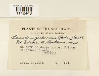 Leucodon julaceus (Hedw.) Sull. 379638[1142448]Palmer, E.J. 71741915-04-10 United States, Arkansas, Hempstead |
MIN:Bryophytes |  Coscinodon raui (Aust.) Lesq. & James 641035[1150289] s.n.1853-08-13 United States, Arkansas, Arkansas River. |
MIN:Bryophytes |  Pleurochaete squarrosa (Brid.) Lindb. 747863[1152872]Anderson, Lewis E. 9511957-07-30 United States, Arkansas, Stone, south of Calico Rock |
MIN:Bryophytes |  Pellia epiphylla (L.) Corda 501049[1179508] United States, Arkansas |
1
Page 1, records 1-16 of 16
Google Map
Google Maps is a web mapping service provided by Google that features a map that users can pan (by dragging the mouse) and zoom (by using the mouse wheel). Collection points are displayed as colored markers that when clicked on, displays the full information for that collection. When multiple species are queried (separated by semi-colons), different colored markers denote each individual species.